The Pacific Tourist by Henry T. Williams, 1876
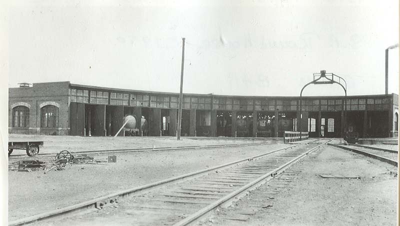
Carlin, — 585 miles from San Francisco, at an elevation of 4,897 feet. It is a railroad town, the terminus of a freight division of the road and the location of the roundhouse, machine car and repair shops of the Humboldt Division of the Central Pacific Railroad. It is the headquarters of Mr. G.W. Coddington, the Division Superintendent. The division extends from Toano to Winnemucca, and this place is about half way between them. The town has no business outside of the railroad shops and employees, and numbers about 200 people. The roundhouse has 16 stalls for engines, and the repair shop, six pits. It is in Elko County. The old emigrant road divided just before reaching Carlin, one branch going south of the river, and the range of mountains bordering the same, and the other going north of the hills on the north side of the river. These two roads came together below near Gravelly Ford. In the vicinity of Carlin the four little creeks come in from the north. In the order in which they are crossed, they are called Susie, Maggie, Mary, and Amelia. Tradition says in regard to these names, that an emigrant was crossing the plains with his family at an early day, and that in this family were four daughters in the order given, and that as the party came to these streams, they gave the name of each one of the daughters to them –a very appropriate thing to do, and their names have been perpetuated in history. Just east of Moleen Station, the tourist looking off to the left, will notice the break or gorge through the low hills, on the south side of the river. Through this gorge the South Fork of the Humboldt comes in. This stream rises in the Ruby Range of Mountains and lows in a general westerly direction, uniting with the main river at this point. We will here state that nearly all the people in the vicinity, call the range of mountains last alluded to “Ruby”, and we have followed the custom; but Lieutenant Wheeler’s Map speaks of it as the Humboldt Range, and according to the custom of the people along this valley, nearly every range of mountains in sight, from one side of the State to the other, is called “Humboldt Range” or “Humboldt Mountains.” As to the fertility of these and other valleys in this part of the State, it all depends upon irrigation. A sage brush plain indicates good soil, but water must be obtained to raise a crop. An effort has been made to make Carlin the shipping point to the mining districts on the north, but without much success thus far. The iron horses are changed here, and with a fresh steed we pass down the valley. It is quite wide here, but will soon narrow as we enter the Twelve Mile Canon. Like the former, the road winds around the base of the bluffs and almost under the ledges, with the river sometimes almost under us. The peaks and ledges seem to have no local name, but some of them are very singular. In one place, soon after entering the canon, the ledges on the right side of the track seem to stand up on edge, and broken into very irregular, serrated lines, –the teeth of the ledge being uneven as to length. The height of the bluffs and of the palisades below, is about the same as in the former canon – 800 feet. In some places the palisades are hollowed out like caves or open arches, and the debris that has crumbled and fallen from their summits during the ages, obscures their form and height from view.
Fifteen Mile Canon, in the Palisades, was graded in six weeks by the Central Pacific Railroad Company, one cut herein containing 6,600 cubic yards. Five Mile Canon just eastward, was graded in three weeks, with a force of 5,000 to 6,000 men.
With the perpendicular walls rising on each side of us, we glide around the curves, and in the midst of these reddish lines of towering rocks, arrive at Palisade.